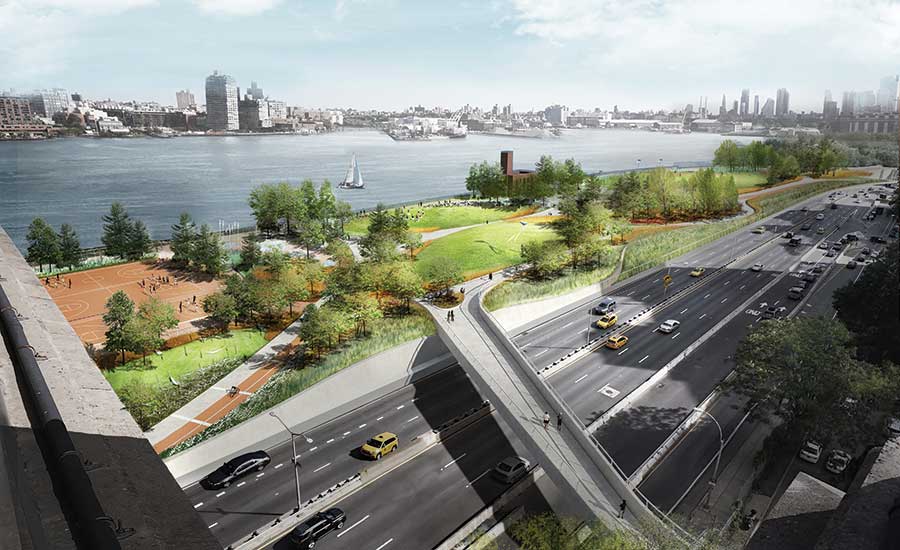
A rendering of the East Side Coastal Resiliency Project shows how parks and berms can play a role in combating storm surge.

After Superstorm Sandy brought the reality of sea-level rise home to New York City, city leaders and the community responded. As a result of hundreds of meetings and a design competition over the past five years, New York now has “Big U,” a planned flood-protection system that will run from West 57th Street down to Battery Park and then back up to East 42nd Street. It incorporates not only walls and levees but also parks and pedestrian plazas.
One of the two major projects is the East Side Coastal Resiliency Project, a 2.4-mile coastal protection project still in the planning stages. It aims to lower risks for the flood-vulnerable neighborhoods from Montgomery Street on Manhattan’s Lower East Side to East 25th Street, including the Financial District. The second major job is the under-construction Broad Channel Street Raising Project, which is located in Queens and designed to curb flooding from the nearby Jamaica Bay.
“The ESCR process is an example of the great accomplishments that come from community organizing and collaboration between the community board, local stakeholders and the mayor’s office,” says Jamie Rogers, chair of Community Board 3, one of the groups involved in the planning process.
The project, selected through a design competition, is expected to break ground in 2019. One component will include work at East River Park, where berms will be placed between FDR Drive and the park to combat sea-level rise and storm surge. The plan—being designed by AKRF, BIG, Arcadis and Turner Construction, among others—will incorporate pedestrian bridges and a jogging and biking path.
NY & NJ In a worst-case scenario, researchers modeled the frequency of storms like Superstorm Sandy increasing 17-fold by the year 2100.
The project is being designed to a 100-year storm in 2050 under high sea-level-rise projections, which are equivalent to midrange projections for 2100. The foundations for the flood protection structures are being built for a 500-year storm in 2050 to accommodate higher structures in the future.
Work also will occur at Stuyvesant Cove, where the entire park will be elevated roughly 9 ft, with a wall in the back of the park serving as flood protection.
The ESCR project is funded by the federal and city government and led by the NYC Dept. of Design and Construction, in conjunction with the Dept. of Parks and Recreation, NYC Dept. of Transportation, NYC Dept. of Environmental Protection and the Mayor’s Office of Recovery and Resiliency. The U.S. Dept. of Housing and Urban Development provided the city with $335 million in Community Development Block Grant-Disaster Recovery funds.
The city and state allotted $7.25 million for planning and conceptual design for the area, and an additional $108 million of capital funding has been set aside for the first phases of project implementation.
“The ESCR Project is the first piece of a larger effort to enhance coastal protection across the city,” says Jainey Bavishi, director of the city’s Office of Recovery and Resiliency.
Author: Alisa Zevin